Chapter 1: Introduction to Geographic Science
The goals and objectives of this chapter are to:
- Recognize the history and evolution of the geographic profession.
- Explain the science of geography today.
- Summarize the basic components of spatial thinking
- Describe the geographic grid system of Earth.
- Explain the overarching concept of geospatial technology and the technologies it includes.
Introduction
When you think of geography do you think about memorizing capitals, rivers, mountains, and states or coloring maps? Sadly, this is how geography is taught too often in K12 schools. In reality, geography is one of the most high-tech scientific disciplines in the science community. Geography is the scientific study of the earth and is one of the original disciplines along with philosophy in trying to understand the world humans live in. The geographic discipline has two sub-categories, physical geography and cultural geography, which allows geographers the scientific credibility to look at cultural issues of economics, demographics, culture, language, religion, or urban planning. It also allows geographers to focus on climate, climate change, biogeography, geomorphology, or environmental issues of pollution, desertification, deforestation, or species extinction. (I would love to see each of the major terms in the previous sentence have a “mouse hover event” so a student can hover and see a very short definition of what each is. Example: I looked up biogeography and fount this in the free dictionary: study of geographic distribution of organisms.)This unique ability also allows geographic scientists to study how the cultural environment influences the physical environment and vice versa. So geography is a physical science and social science, (ditto for physical science and social science so learners can see the difference) but also has the academic credibility to study the interaction between the two.
What makes the scientific discipline of geography different from other science disciplines is its emphasis on space, place, and connection. The technology geographers and other scientists use to study the physical and cultural environments spatially and over time is with geospatial technology. Geospatial technology is an umbrella term that encompasses global positioning systems (GPS), remote sensing (i.e. satellite imagery and aerial photography), and geographic information systems (GIS). Teaching a geography class without teaching about geospatial technology would be like a chemistry teacher teaching about chemistry without ever using the periodic table.
What makes the scientific discipline of geography different from other science disciplines is its emphasis on space, place, and connection. The technology geographers and other scientists use to study the physical and cultural environments spatially and over time is with geospatial technology. Geospatial technology is an umbrella term that encompasses global positioning systems (GPS), remote sensing (i.e. satellite imagery and aerial photography), and geographic information systems (GIS). Teaching a geography class without teaching about geospatial technology would be like a chemistry teacher teaching about chemistry without ever using the periodic table.
History of the Geographic Discipline
Image copyright: James Forsyth, licensed under Creative Commons Attribution Non-commercial 2.0
Geography is often times called the “mother of all sciences” because geography is one of the earliest known scientific disciplines that date back to the original Homo-sapiens who migrated out of eastern Africa, into Europe, Asia, and beyond. In fact, some would argue that spatial awareness and early mapping were more significant to the development and migration of humans out of Africa than language. There is no single, linear or historic pathway through the cultural development of geography because the discipline is inherently human. Humans have always had a need and desire to explore their surroundings, expand their influence and sometimes dominance over new lands.
Modern geography probably originated in Western Europe during the 16th century as the region experienced economic and social growth, as well as upheaval brought about by new navigational methods and colonization. Geography, as a formal discipline, came about as sailing and trade routes across the great oceans become more common. This required new knowledge in navigation, mathematics, literacy, science, medicine, warfare, and of course, cartography (map making). A cartographer is someone who is skilled in the science and art of map-making. Some scholars whom research concepts of critical cartography have posited that modern mapping is grounded in power, dominance, control, war, racism, and the dismantling of foreign cultures. Thus, maps in the past, present, and future will play a powerful role in how we understand the world because maps help shape our sense of place, and those who create the maps often shape our historical, cultural, and political interactions with place.
Alexander von Humboldt and Carl Ritter, according to many in the field, took geography from a primarily navigation-oriented discipline to more scholarly pursuits. Both scholars wanted to understand the natural and human environments from a systematic and objective perspective as a way to explain specific regions of the world. Over time, academic and institutionalized organizations of geographic research grew throughout Europe. The need for skilled geographers and cartographers grew ever more important to countries because they provided the powerful and elite detailed surveys and spatial information about the physical and cultural environments they wanted to explore and exploit. This was especially true as colonial powers desired the resources (natural and human), and the prestige of controlling Africa in the 1800s.
Geography transformed from a discipline centered on navigation to a pathway for imperial exploration, and then to a discipline of imperial science. Sadly, many geographers took Charles Darwin’s ideas of evolution and natural selection and applied them to a perverted interpretation called Social Darwinism. This idea, first constructed by economists in Europe, implies that natural selection could easily be applied to social and political concepts. It was Social Darwinists that coined the term “survival of the fittest,” not Charles Darwin. Under this hypothesis, natural selection could be used to justify the need for “stronger” nation-states or races to dominate over “weaker” nation-states and races.
Social Darwinism later grew into scientific racism. This became a systematic problem throughout the discipline of geography because it justified European explorers and settlers’ ideas that they were genetically superior to other races, as well as entitled and destined to expand their civilizations and belief systems as they had been doing for over 400 years. This included European settlers in the Americas or “New World.”
World Wars I and II caused a major shift in geographic thought. By this time, most of the world had been navigated, explored, and in essence, colonized. Any new expansion would likely require colonial powers to conquer each other. Many geographers played a leading role in advising national leaders on Post-war Reconstruction and a new era of geography was born. Geographers understood the need to merge scientific thoughts in physical and cultural geography when trying to understand a region of the world and to value diversity and uniqueness within these regions grounded within spatial science.
Science of Geography Today
As stated earlier, geographers study both the physical, environmental, and cultural aspects of the world. Besides being called the “mother science,” some say that geographers "are a mile wide and an inch deep” because geographers have to know a lot about the physical, environmental, or cultural world, but may not go into the depth that other disciplines might. Since so many disciplines have branched off from geography, the discipline of geography has had to find its own focus, emphasis, and depth.
Image copyright: James Forsyth, licensed under Creative Commons Attribution Non-commercial 2.0
|
Image copyright: James Forsyth, licensed under Creative Commons Attribution Non-commercial 2.0
|
Physical geography focuses on natural origins and processes of the physical earth. Some physical geographers focus on environmental issues and are called environmental geographers, a sub-discipline of physical geography. Physical geographers focus on weather, climate and climate change, landforms, environmental pollution, river processes, and more. Cultural geographers emphasize human endeavors such as population, language, religion, culture and ethnicity, economics and development, geopolitics, urban planning, and more. Geographers in this line of science are often called human geographers.
Ultimately, the entire geography profession is focused on the spatial distribution or arrangement of the physical and cultural world. One of the discipline’s greatest strengths and contributions to science and society is their study of interrelationships between physical and cultural elements of the earth’s environment. Maybe it's the interrelationship between river systems and soil, or climate and ecosystems, or even the connections between deforestation, species extinction, population growth, and poverty issues. The interconnectedness of all areas of geography often requires many geographers to train in both physical and cultural geography. In fact, probably the greatest strength of the science of geography is the discipline's ability to study the world spatially and look for the interconnections between the physical and cultural environments.
Ultimately, the entire geography profession is focused on the spatial distribution or arrangement of the physical and cultural world. One of the discipline’s greatest strengths and contributions to science and society is their study of interrelationships between physical and cultural elements of the earth’s environment. Maybe it's the interrelationship between river systems and soil, or climate and ecosystems, or even the connections between deforestation, species extinction, population growth, and poverty issues. The interconnectedness of all areas of geography often requires many geographers to train in both physical and cultural geography. In fact, probably the greatest strength of the science of geography is the discipline's ability to study the world spatially and look for the interconnections between the physical and cultural environments.
The Scientific Process of Geography
Geography is considered a science and thus also uses the scientific method for data collection, analysis, and interpretation. There is no true definition of the scientific method because it varies so much between scientific disciplines. There are various methods to acquire scientific knowledge from the physical sciences, biological sciences, social sciences, and everything in between. A simplified version of what most scientific disciplines follow are:
- Observe a particular feature, phenomenon, or event in the world that stimulates a series of questions and thought process.
- Develop an educated thought that tries to answer the questions posed, called a hypothesis.
- Design an experiment or way to "test" your hypothesis.
- Implement the experiment and observe the results using unbiased data and measurement techniques.
- Propose a solution, answer, or rule that explains the hypothesis and experiment.
Spatial Thinking and Analysis
Above all else, geography is considered a spatial science. It is concerned with the spatial behavior of people, with the spatial relationships that are observed between places on the earth’s surface, and with the spatial processes that create or maintain those behaviors and relationships. Geographers are concerned the intersections between space (aerial extent) and place. Place is a particular area or point on Earth that has a particular characteristic. Every place on earth has a unique location physically and conceptually. A region is an area on the earth's surface that has distinctive physical and cultural characteristics. A very important concept in geography is scale, which is the relationship between the locations of something on the earth compared to the entire earth. Scale can range from the atomic level to the entire planet or even space. Connection is the relationship between the physical or cultural components of the world, (or both), that crosses barriers and boundaries.
LOCATION
Location is probably one of the most significant aspects of the discipline, which is a position of an object that could be put on a map. That location doesn’t need to be on the Earth’s surface, it can be below, within the oceans, the atmosphere, or even in space. Location can also be divided into nominal, relative, and absolute. Nominal locations are the names of a place. Examples include Washington D.C., the Rocky Mountains, the Nile River, or Florida. Nominal locations just specify a location’s name and their scale can vary.
Relative location is a very common form of location. How often have you given directions to your house using landmarks rather than just your address? Relative location is the location of something relative to other features. You can understand a lot about a place based on what’s around it.
The third kind of location is called absolute location, which is the particular location of something. This is usually based on some sort of geographic coordinate system like latitude and longitude. If you think about it, many navigation GPS systems use relative and absolute locations. If you were to type in an address and used your current location as the starting point into a mapping system like Google Maps, it will not only give you the location of your destination, it will also give you a few relative pathways to get there.
DIRECTION
Next in our study of spatial thinking is direction and distance. Direction is the location of something relative to something else. If we refer back to our example with Google Maps, an online program will determine a direction based on your current location and your intended destination. Distance is a mathematical concept and used to determine the space between two or more features using some form of measuring unit. A simple example of this would be using Google Maps to determine the distance from Salt Lake City, Utah to Portland, Oregon shown above, which is about 766 miles per hour.
Geographers are also concerned with issues of space. In particular, they are concerned with what exists between spaces. Are the features between the spaces related or similar to each other or dissimilar? The 1st Law of Geography states they are likely to be related, but that isn’t always the case. Networks are concerned with the movement or flow of an object through space and time. This can apply to transportation, migration, trade, flow of rivers, glacier, or the atmosphere, and also the flow of cyber networks.
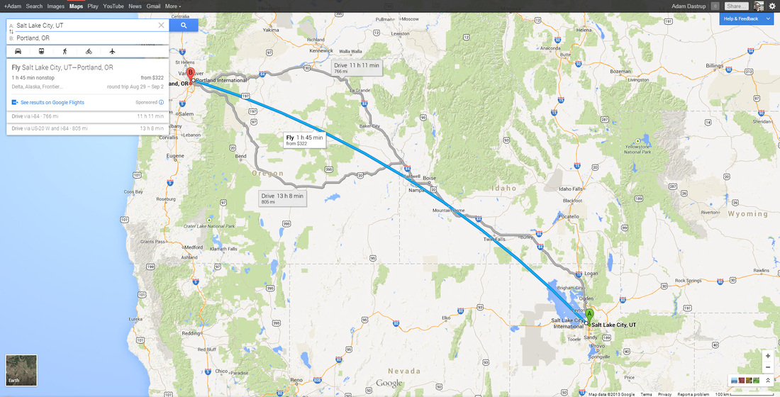
Image Image copyright: Google
Next in our study of spatial thinking is direction and distance. Direction is the location of something relative to something else. If w
The Geographic Grid
Geography is about spatial understanding, which requires an accurate grid system to determine absolute and relative location. Absolute location is the exact x- and y- coordinate on the Earth. Relative location is the location of something relative to other entities. For example, when you use your GPS in your smart phone or car, say Google Maps, you put in an absolute location. But as you start driving, the device tells you to turn right or left relative to objects on the ground: "Turn left on exit 202"is relative to the other exit points. Or if you give directions to your house, you often use relative locations to help them understand how to get to your house.

GREAT AND SMALL CIRCLES
Much of Earth's grid system is based on the location of the North Pole, South Pole, and Equator. The poles are an imaginary line running from the axis of Earth's rotation. The plane of the equator is an imaginary horizontal line that cuts the earth into two equal halves. This brings up the topic of great and small circles. A great circle is any circle that divides the earth into a circumference of two equal halves. It's also the largest circle that can be drawn on a sphere. The line connecting any points along a great circle is also the shortest distance between those two points. Examples of great circles include the Equator, all lines of longitude, the line that divides the earth into day and night called the circle of illumination , and the plane of ecliptic, which divides the earth into equal halves along the equator. Small circles are circles that cut the earth, but not into equal halves. Examples of small circles include all lines of latitude except the equator, the Tropical of Cancer, Tropic of Capricorn, the Arctic Circle, and Antarctic Circle.
Much of Earth's grid system is based on the location of the North Pole, South Pole, and Equator. The poles are an imaginary line running from the axis of Earth's rotation. The plane of the equator is an imaginary horizontal line that cuts the earth into two equal halves. This brings up the topic of great and small circles. A great circle is any circle that divides the earth into a circumference of two equal halves. It's also the largest circle that can be drawn on a sphere. The line connecting any points along a great circle is also the shortest distance between those two points. Examples of great circles include the Equator, all lines of longitude, the line that divides the earth into day and night called the circle of illumination , and the plane of ecliptic, which divides the earth into equal halves along the equator. Small circles are circles that cut the earth, but not into equal halves. Examples of small circles include all lines of latitude except the equator, the Tropical of Cancer, Tropic of Capricorn, the Arctic Circle, and Antarctic Circle.

|
.png)
|
LATITUDE AND LONGITUDE
Many think that latitude is a line connecting points on the earth and it's not. Latitude is actually an angular measurement north or south of the equator (image on the left). So 30 degrees north means a point that is 30 degrees north of the equator. Latitude is also expressed in degrees, minutes, and seconds; 360 degrees in a circle, 60 minutes ( ' ) in a degree, and 60 seconds ( " ) in a minute. When you use Google Earth, the coordinate locations are in this degrees/minutes/seconds format. Latitude varies from 0 degrees (equator) to 90 degrees north and south (the poles).
A line connecting all points of the same latitude is called a parallel, because the lines run parallel to each other. The only parallel that is also a great circle is the equator. All other parallels are small circles. The following are the most important parallel lines:
- Equator, 0 degrees
- Tropic of Cancer, 23.5 degrees N
- Tropic of Capricorn, 23.5 degrees S
- Arctic Circle, 66.5 degrees N
- Antarctic Circle, 66.5 degrees S
- North Pole, 90 degrees N (infinitely small circle)
- South Pole, 90 degrees S (infinitely small circle)
Latitude is also sometimes described as zones of latitude. Some of these zones of latitude include:
- Low latitude - generally between the equator and 30 degrees N
- Midlatitude - between 30 degrees and 60 degrees N and S
- High latitude - latitudes greater than about 60 degrees N and S
- Equatorial - within a few degrees of the equator
- Tropical - within the tropics (between 23.5 degrees N and 23.5 degrees S
- Subtropical - slightly pole-ward of the tropics, generally around 25-30 degrees N and S
- Polar - within a few degrees of the North or South Pole
Longitude is the angular measurement east and west of the Prime Meridian (image on the right). Like latitude, longitude is measured in degrees, minutes, and seconds. Lines connecting equal points of longitude are called meridians. But unlike parallels, meridians do not run parallel to each other. Rather they are farthest apart from each other at the equator and merge toward each other toward the poles. The problem with longitude is that there isn't a natural baseline like the equator is for latitude. For over a hundred years, nations used their own "prime meridian" which proved problematic for trade. But in 1883 an international conference in Washington D.C. was held to determine a global prime meridian. After weeks of debate, the Royal Observatory at Greenwich, England was determined as the Greenwich Meridian or also called the prime meridian for the world. So today, longitude starts at the Prime Meridian and measures east and west of that line.
At 180 degrees of the Prime Meridian in the Pacific Ocean is the International Date Line. The line determines where the new day begins in the world. Now because of this, the International Date Line is not actually a straight line, rather it follows national borders so that a country isn't divided into two separate days (and we think hour time zones are a pain). If you look at the map above, the International Date Line is to the right in a dark, black line. Note how it is drawn to make sure nations are not divided by the International Date Line.
At 180 degrees of the Prime Meridian in the Pacific Ocean is the International Date Line. The line determines where the new day begins in the world. Now because of this, the International Date Line is not actually a straight line, rather it follows national borders so that a country isn't divided into two separate days (and we think hour time zones are a pain). If you look at the map above, the International Date Line is to the right in a dark, black line. Note how it is drawn to make sure nations are not divided by the International Date Line.

This is also a good time to take a look at time zones around the world. If you refer back to the map above, you can see the different time zones in the various colors. Since the earth rotates 360 degrees in a 24 hour period, the earth rotates 15 degrees every hour. In an ideal world, each time zone would follow lines of longitude every 15 degrees (7.5 degrees in each direction from the center of the time zone). But because of political boundaries, time zones are not divided up so perfectly and vary greatly in shape and width.
Greenwich, England was chosen in the mid-nineteenth century as the starting point of time worldwide. The reason was because at the time, England was the superpower of the time both militarily and economically. So the meridian that ran through Greenwich became zero degrees or the prime meridian. Because of the earth’s rotation in reference to the prime meridian, locations east of the new meridian meant time was ahead while locations west of the meridian were behind in time in reference to Greenwich, England.
Ultimately, when you combine parallel and meridian lines, you end up with a geographic grid system that allows you to determine your exact location on the planet.
Big Data and Spatial Data
Data is everywhere, especial big data and spatial data. Big data refers to the fact that their is so much data that we can now not only understand the physical and cultural world, but we can start to predict behavior. Big data can determine who your friends are, what your buying habits are and what you are willing to impulse buy. It allows businesses to determine what your purchasing power is and what draws you. Scientists use it to understand complex "systems" such as ecological processes, weather patterns, and climate change.
Spatial data is now a form of bid data. It’s collected every time you go to the grocery store and use their card to reduce the costs, when you click on a link on Facebook, or when you do any kind of search on a search engine like Google, Bing, or Yahoo!. It is used by your state department of transportation when you are driving on a freeway or when you use an app on a smart phone. Futurists believe that in the near future, face recognition technology will allow a sales representative know what types of clothes you like to buy based on a database of your recent purchases at their store and others.
Now there are two basic types of data you need to know: spatial and non-spatial data. Spatial data, also called geospatial data, is data that can be linked to a specific location on Earth. Geospatial data is becoming “big business” because it isn’t just data, but data that can be located, tracked, patterned, and modeled based on other geospatial data. Census information that is collected every 10 years is an example of spatial data. Non-spatial data is data that cannot be specifically traced to a specific location. This might include the number of people living in a household, enrollment within a specific course, or gender information. But non-spatial data can easily become spatial data if it can be linked in some way to a location. Geospatial technology specialists have a method called geocoding that can be used to give non-spatial data a geographic location. Once data has a spatial component associated with it, the type of questions that can be asked dramatically changes.
Geospatial Technology
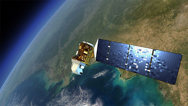
REMOTE SENSING
Remote sensing can be defined as human’s ability to study objects without being in direct physical contact with them. So for example, your eyes are a form of passive remote sensing because they are “passively” absorbing electromagnetic energy within the visible spectrum from distant objects and your brain is processing that energy into information. There are a variety of remote sensing platforms or devices, but they can basically be categorized into the following that we will look at throughout the course.
Remote sensing can be defined as human’s ability to study objects without being in direct physical contact with them. So for example, your eyes are a form of passive remote sensing because they are “passively” absorbing electromagnetic energy within the visible spectrum from distant objects and your brain is processing that energy into information. There are a variety of remote sensing platforms or devices, but they can basically be categorized into the following that we will look at throughout the course.
|
Satellite imagery is a type of remotely sensed imagery taken of the Earth's surface, which is produced from orbiting satellites that gather data via electromagnetic energy. Next is areal photography, which is film-based or digital photographs of the Earth, usually from an airplane or non-piloted drone. Images are either taken from a vertical or oblique position. Third is radar, which is an interesting form of remote sensing technology that uses microwave pulses to create imagery of features on Earth. This can be from a satellite image or ground-based Doppler radar for weather forecasting. Finally, a fast growing realm of remote sensing is called Light Detection and Ranging or Lidar, which is a form of remote sensing that measures distance of objects using laser pulses of light.
|
|
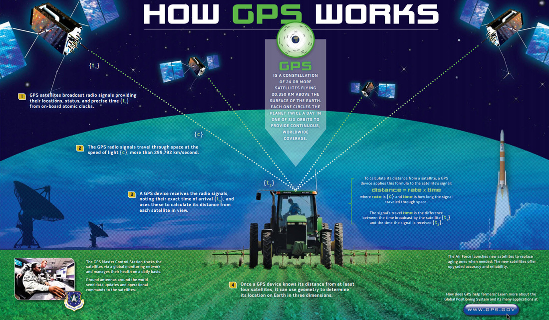
GLOBAL POSITIONING SYSTEMS
Another type of geospatial technology is global positioning systems (GPS) and a key technology for acquiring accurate control points on Earth’s surface. Now to determine the location of that GPS receiver on Earth’s surface, a minimum of four satellites are required using a mathematical process called triangulation. Normally the process of triangulation requires a minimum of three transmitters, but because the energy sent from the satellite is traveling at the speed of light, minor errors in calculation could result in large location errors on the ground. Thus, a minimum of four satellites is often used to reduce this error. This process using the geometry of triangles to determine location is used not only in GPS, but a variety of other location needs like finding the epicenter of earthquakes.
A user can use a GPS receiver to determine their location on Earth through a dynamic conversation with satellites in space. Each satellite transmits orbital information called the ephemeris using a highly accurate atomic clock along with its orbital position called the almanac. The receiver will use this information to determine its distance from a single satellite using the equation D = rt, where D = distance, r = rate or the speed of light (299,792,458 meters per second), and t = time using the atomic clock. The atomic clock is required because the receiver is trying to calculate distance, using energy that is transmitted at the speed of light. Time will be fractions of a second and requires a “time clock” up the upmost accuracy.
GEOGRAPHIC INFORMATION SYSTEMS
There is a technology that exists that can bring together remote sensing data, GPS data points, spatial and non-spatial data, and spatial statistics into a single, dynamic system for analysis and that is a geographic information system (GIS). A GIS is a powerful database system that allows users to acquire, organize, store, and most importantly analyze information about the physical and cultural environments. A GIS views the world as overlaying physical or cultural layers, each with quantifiable data that can be analyzed. A single GIS map of a national forest could have layers such as elevation, deciduous trees, evergreens, soil type, soil erosion rates, rivers and tributaries, major and minor roads, forest health, burn areas, regrowth, restoration, animal species type, trails, and more. Each of these layers would contain a database of information specific to that layer.
Nearly every discipline, career path, or academic pursuit uses geographic information systems because of the vast amount of data and information about the physical and cultural world. Disciplines and career paths that use GIS include: conservation, ecology, disaster response and mitigation, business, marketing, engineering, sociology, demography, astronomy, transportation, health, criminal justice and law enforcement, travel and tourism, news media, and the list could endlessly go on.
Now, GIS primarily works from two different spatial models: raster and vector. Raster based GIS models are images much like a digital picture. Each image is broken down into a series of columns and rows of pixels and each pixel is georeferenced to somewhere on Earth's surface is represents a specific numeric value - usually a specific color or wavelength within the electromagnetic spectrum. Most remote sensing images come into a GIS as a raster layer. The other type of GIS model is called a vector model. Vector based GIS models are based on the concept of points that are again georeferenced (i.e. given an x-, y-, and possibly z- location) to somewhere specific on the ground. From points, lines can be created by connecting a series of points and areas can be created by closing loops of vector lines. For each of these vector layers, a database of information can be attributed to it. So for example, a vector line of rivers could have a database associated with it such as length, width, stream flow, government agencies responsible for it, and anything else the GIS user wants tied to it. What these vector models represent is also a matter of scale. For example, a city can be represented as a point or a polygon depending on how zoomed in you are to the location. A map of the world would show cities as points, whereas a map of a single county may show the city as a polygon with roads, populations, pipes, or grid systems within it.
Now more then ever society has access to spatial information through the use of geospatial technology, which is directly influencing how we understand the physical and cultural environments we live in. Recently the Washington Post had two articles on how maps help us understand our world titled 40 Maps That Explain Our World and 40 More Maps That Explain Our World. The images below are satellite images from NASA and proved by NASA's Earth Observatory. Click on the thumbnails to see a large image and click on the those to get detailed information for each satellite image. All of the images in this eTextbook are free and licensed as Creative Commons. By clicking on any image, you will be directed to the original source.
Summary
Geography is a unifying discipline of research that helps us understand the physical, environmental, and cultural environments with an emphasis in interconnections and spatial dynamics between these environments. The discipline of geography has had a long history starting back to the time of the earliest explorers, through the colonial era of power, territory, and domination, and today as a scientific discipline based on empirical evidence using the scientific method. Because geographers look at the physical and cultural world, most geographers are trained in both physical, natural, and social sciences in order to understand how each influences the other. Geography is also an important spatial science and uses geospatial technology to understand the various environments spatially and over time. This is done by using technologies such as satellite imagery, aerial photography, global positioning systems and geographic information systems to name a few. It also requires geographers to have a strong background in spatial thinking and analysis to understand patterns, connects, and pathways between the physical and cultural environments.
Photo from dsearls
