Chapter 3: Earth's Atmosphere
The goals and objectives of this chapter are to:
- Explain how incoming solar radiation influences weather and climate patterns.
- Describe how the atmosphere is warmed from the ground up.
- Identify how energy is transferred around the planet.
- Describe the basic elements of weather.
- Analyze how atmospheric stability, air masses, and weather fronts influence weather patterns
- Describe how atmospheric pollution is created by natural processes and human activity
- Explain how atmospheric pollution affects human health
Introduction
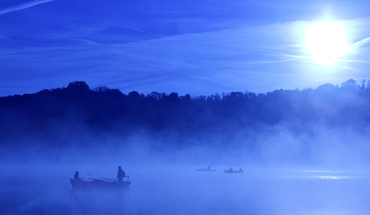
Atmospheric processes and energy exchanges are driven by Earth's energy balance and linked to climate and weather. Hurricanes, thunderstorms, tornadoes, blizzards, ice storms, dust storms, heat waves, as well as flash flooding resulting from intense precipitation, are all natural processes that are hazardous to people. These severe hazards affect considerable portions of Northern America and are responsible for causing significant death and destruction each year. But in order to understand topics such as thunderstorms, tornadoes, lightning, and hurricanes, we need to spend some time looking at the basics of weather.
|
|
|
Incoming Solar Radiation
|
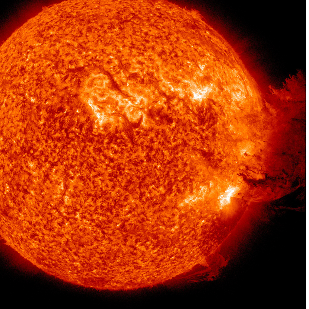
The Sun is the driving force of our weather and climate. Its diameter is about 865,000 miles or 109 Earths lined up side by side and is so large that it makes up 99.99 percent of the mass of our Solar System. Our star - the Sun - is the most common type of star in the universe and has existed for nearly 4.6 billion years.
The composition of the Sun is about 92 percent hydrogen (the lightest element in the universe) and almost 8 percent helium (the second lightest element). Using these elements, the Sun generates energy through a process called thermonuclear reaction. This energy is created when the Sun fuses together hydrogen atoms to make a heavier element called helium. This process not only creates new elements, but also releases an enormous amount of energy. |
|
|
|
|
The energy emitted by the Sun is called electromagnetic energy, which travels at the speed of light in a spectrum of various wavelengths. (Recall from the module on tsunamis that a wavelength is the distance between two wave crests and frequency is the number of wavelengths that pass a given point in a given amount of time.)
The sun's life expectancy is already half over and in another 4 billion years it will consume all the hydrogen within it leaving behind helium and a few other newly created elements. When the hydrogen runs out, in about 5 billion years, the sun will grow into a red giant, expanding its diameter well past Mercury and possibly Venus and Earth. The sun will continue to fuse helium into carbon until it begins to release its outer layers to form a planetary nebula. Left behind will be the white hot core of our star, called a white dwarf, that will slowly fade out over billions of years.
The sun's life expectancy is already half over and in another 4 billion years it will consume all the hydrogen within it leaving behind helium and a few other newly created elements. When the hydrogen runs out, in about 5 billion years, the sun will grow into a red giant, expanding its diameter well past Mercury and possibly Venus and Earth. The sun will continue to fuse helium into carbon until it begins to release its outer layers to form a planetary nebula. Left behind will be the white hot core of our star, called a white dwarf, that will slowly fade out over billions of years.
Warming Up the Atmosphere
|
|
Why would you want to wear a black shirt in the winter and a white shirt in the summer? Or would you rather walk barefoot on black pavement or grass? This relates to the idea that different objects absorb and reflect energy differently on the planet. Dark objects tend to absorb more energy, whereas lighter objects reflect more energy. The percent of energy an object reflects is an object's albedo. Because the planet has so many different albedos (cities, forests, deserts, oceans, rocks, glaciers, etc.), the planet has uneven heating on the planet. The result is that of all the energy the Earth receives from the Sun, only 51 percent is actually absorbed by the planet while 49 percent is reflected back into space.
|
Uneven heating of the planet also occurs because of the curvature of the Earth. The planet receives most of its energy near the equator where the Sun's rays are directly (or nearly directly) hitting the planet. As you move toward the poles, the Sun's energy becomes more diffused and spread out over a greater area. Ultimately, the equator receives more energy from the Sun than it can radiate back into space. There is a surplus of energy. At the poles, the planet radiates more energy out into space than it receives from the Sun. There is a deficit of energy in these regions. The ultimate purpose of weather is to transfer the surplus of energy and heat to the poles and bring colder air toward the equator and find equilibrium.
|

Diagram created by Peter Halasz and licensed as Creative Commons.
|
Global Transfer of Heat
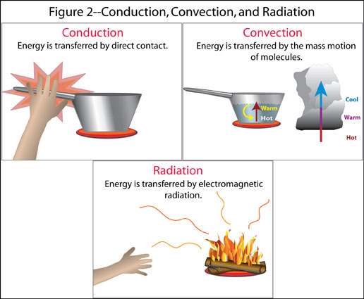
If the planet is trying to balance the extremes of the poles and equator, how is heat transferred around the planet? There are four ways: conduction, convection, latent heat, and radiation.
CONDUCTION
Conduction is the transfer of heat from a warmer object to a cooler object through molecule interaction. As the Sun heats the ground, energy is transferred to the atmosphere by conduction. But the atmosphere is a very poor conductor of heat. In calm weather, the heated ground only warms the first few centimeters of air. In fact, the atmosphere's temperature can be 50 percent colder at your head than near your feet. Since the atmosphere is such a poor conductor of heat, there must be other ways to transfer the energy.
CONVECTION
Convection is the transfer of heat by the mass movement of a fluid (such as water and air). It occurs mostly in liquids and gases because they are free to move around. Heat is transferred upward and outward away from its heat source and cooler air is brought in to replace the rising air. On a local scale convection in the summer can produce afternoon thunderstorms, but on a global scale convection transfers energy from the equator toward the poles and back.
RADIATION
The final process of transferring heat around the planet is called radiation. The energy coming from the Sun comes in various wavelengths. A wavelength is the distance measured along a wave of energy from one crest to another; the shorter the wavelength, the higher the energy. The energy received from the Sun passes through the atmosphere without warming it. But all objects that absorb radiation from the sun radiate some of that energy back out in a weaker form of energy called long wave radiation such as heat. All living objects (including humans) radiate longwave radiation. The Earth itself radiates the energy absorbed from the Sun in the form of longwave radiation which is sometimes called Earth light. If you were an astronaut wearing infrared goggles, you would actually see the earth glowing from the radiating infrared radiation.
LATENT HEAT
Latent heat, also called a phase change, is a powerful force in weather. When water transforms from gas to liquid or solid (or vise versa), it is called a phase change. The heat required to change phases is called latent heat. In order for water to change from a liquid to a gas, energy/heat must be taken from some external source such as the surrounding atmosphere. Therefore, evaporation is a cooling process because the water is taking heat from the surrounding air in order to evaporate. With the image above, visualize that every time evaporation or condensation occurs, there is a direct transfer of heat and energy.
The process of evaporation and condensation transfers large amounts of heat around the planet. The heat released in a typical thunderstorm is equal to an atomic bomb. The heat/energy within a hurricane is equal to 100,000 atomic bombs and could power the United States for over a year!
The process of evaporation and condensation transfers large amounts of heat around the planet. The heat released in a typical thunderstorm is equal to an atomic bomb. The heat/energy within a hurricane is equal to 100,000 atomic bombs and could power the United States for over a year!
Elements of Weather
CONTROLS OF TEMPERATURE
There are several controlling factors that determine global temperatures. The first and most significant is latitude. Because of the Earth’s shape the angle of the Sun hitting the planet, temperatures are greatest near the equator and decrease toward the poles. In fact, at the equator more energy is absorbed from the Sun than is radiated back into space. At the poles, more energy is radiated back into space than is absorbed by the Sun. The purpose of weather and ocean currents is to balance out these two extremes.
The next control of temperature is the distribution of land and water on the planet. Places near the ocean tend to have milder climates year-round versus regions surrounded by land. This is because the earth can heat up and cool down faster and greater than the ocean. The reason is because sunlight must heat a larger volume of area in the ocean because light can pass through water. Water requires 5 times more energy to heat up than earth, called specific heat. Thus, region’s temperatures located near large bodies of water temperatures change slowly compared to land. Ocean currents are also vital controls in transferring heat around the planet. In the Northern Hemisphere, ocean currents rotate clockwise bring cold water from the North Pole toward the equator and warm water from the equator toward the North Pole. The opposite occurs in the Southern Hemisphere.
The next control of temperature is the distribution of land and water on the planet. Places near the ocean tend to have milder climates year-round versus regions surrounded by land. This is because the earth can heat up and cool down faster and greater than the ocean. The reason is because sunlight must heat a larger volume of area in the ocean because light can pass through water. Water requires 5 times more energy to heat up than earth, called specific heat. Thus, region’s temperatures located near large bodies of water temperatures change slowly compared to land. Ocean currents are also vital controls in transferring heat around the planet. In the Northern Hemisphere, ocean currents rotate clockwise bring cold water from the North Pole toward the equator and warm water from the equator toward the North Pole. The opposite occurs in the Southern Hemisphere.
The last control of temperature is elevation. On average, the air decreases in temperature with altitude about 3.6 degrees Fahrenheit per 1000 feet, called the normal lapse rate or temperature lapse rate. Using the Wasatch Front in Utah as an example, Example in Utah: elevation in Salt Lake City is about 6,500 feet above sea level and the Wasatch Mountains elevations are about 10,000 feet above sea level. That’s a 3,500 feet rise in elevation. If it cools at 3.6 degrees Fahrenheit per 1,000 feet, then the top of the mountains are about 12.6 degrees Fahrenheit cooler.
MOISTURE AND HUMIDITY
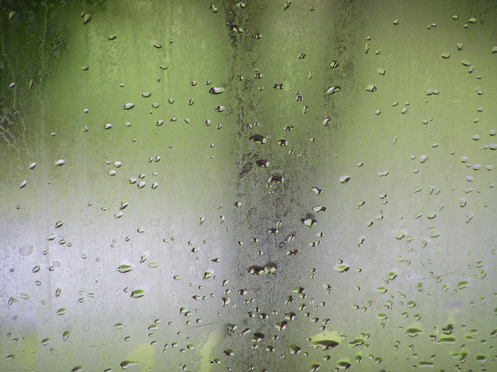
In order for liquid water to evaporate, water molecules must absorb enough energy to break bonds between each other. In order to do this, the liquid water must absorb energy and heat from the surrounding environment called latent heat. If the water vapor absorbs enough energy, they will begin to vibrate fast enough to break their molecular bonds and become individual water molecules or gas. Evaporation is a cooling process because it takes heat from the surrounding environment. The concept of latent heat is really necessary and will come back later on cloud formation and severe weather.
The opposite must occur in order for water vapor to condense into liquid water. In order for fast vibrating water molecules to condense into liquid, it must release latent heat to the surrounding environment. Releasing energy allows the water molecules to slow down their vibration and attach to other water molecules to become liquid. But one step is missing. In order for water vapor to become liquid, it needs something to condense onto – condensation nuclei. Condensation nuclei consist of microscopic dust, smoke, salt particles that float in the air and recently bacteria. In fact, it is believed that bacteria make up nearly half of all condensation nuclei. To summarize, in order for water vapor to condense into small liquid or ice cloud droplets, condensation nuclei must be present.
Humidity is defined as the amount of water vapor in the atmosphere. There are several ways to classify humidity, but for this course we will focus on relative humidity. Relative humidity is the ratio of the atmosphere’s actual water vapor content compared to the amount of water vapor required for atmospheric saturation at that temperature and is usually expressed as a percentage. If the relative humidity is 25 percent, the atmosphere is only holding a quarter of what it could contain. If relative humidity is at 100 percent, the atmosphere is saturated.
There are two ways to change relative humidity: moisture content and/or temperature. If the air temperature, stays the same, but the amount of water vapor is increased or decreased, relative humidity will change. Next, it should first be noted that warm air can “hold” more moisture than cooler air. If the water content stays the same, but temperature increases, relative humidity will decrease. If the water content stays the same, but the temperature decreases, relative humidity will increase.
Relative humidity is just as the name implies; it is a relative measurement. A better direct measurement and analysis of humidity is dew point; the atmospheric temperature air must cool down to in order for it to condense into liquid water or solid ice crystals. So if the dew point is 42 degrees Fahrenheit for a particular geographic location at a particular time, then the current temperature must fall to 42 degrees in order for the air to become saturated. The higher the dew point reading, the less air must cool to become saturated. This means the air is quite humid. The lower the dew point reading, the more air must cool to become saturated; thus the air is quite dry. Dew point analysis is vital for weather forecasting in the summer to determine the likelihood of afternoon thunderstorms. If the humidity is high, providing a high dew point measurement, then afternoon convection does not require the unstable moisture to rise as high in order for condensation and thunderstorms genesis occur. Plus recall that condensation from water vapor to liquid water or ice crystals releases latent heat, a key ingredient for the formation of thunderstorms.
Relative humidity is just as the name implies; it is a relative measurement. A better direct measurement and analysis of humidity is dew point; the atmospheric temperature air must cool down to in order for it to condense into liquid water or solid ice crystals. So if the dew point is 42 degrees Fahrenheit for a particular geographic location at a particular time, then the current temperature must fall to 42 degrees in order for the air to become saturated. The higher the dew point reading, the less air must cool to become saturated. This means the air is quite humid. The lower the dew point reading, the more air must cool to become saturated; thus the air is quite dry. Dew point analysis is vital for weather forecasting in the summer to determine the likelihood of afternoon thunderstorms. If the humidity is high, providing a high dew point measurement, then afternoon convection does not require the unstable moisture to rise as high in order for condensation and thunderstorms genesis occur. Plus recall that condensation from water vapor to liquid water or ice crystals releases latent heat, a key ingredient for the formation of thunderstorms.
|
|
|
ATMOSPHERIC PRESSURE AND WIND
There are various elements that control weather: air pressure, atmospheric stability, Coriolis effect, air masses, and weather fronts. Air pressure is a force created by the weight of the atmosphere. Because of gravity, air pressure is greatest at sea level and decreases with height. There is also high pressure and low pressure.
High pressure, also called an anticyclone, occurs when descending air molecules "pile up" at the surface and spread outward in a clockwise rotation in the Northern Hemisphere (counterclockwise in the Southern Hemisphere). Descending air warms, which prevents water vapor to condense into clouds to produce storms. Instead, regions under high pressure tend to experience clear skies. Low pressure, also called a cyclone, occurs when converging air is forced upward (in a counterclockwise manner in the Northern Hemisphere) where it cools and condenses into clouds and possible storms. Ultimately, air flows from high pressure to low pressure and this is called wind.
If you have high pressure and low pressure, that means there is an imbalance between in air pressure in the atmosphere. The force to balance these two pressure imbalances is called the pressure gradient force, which creates wind. So wind is the horizontal movement of air from high pressure to low pressure to balance atmospheric pressure.

|
|
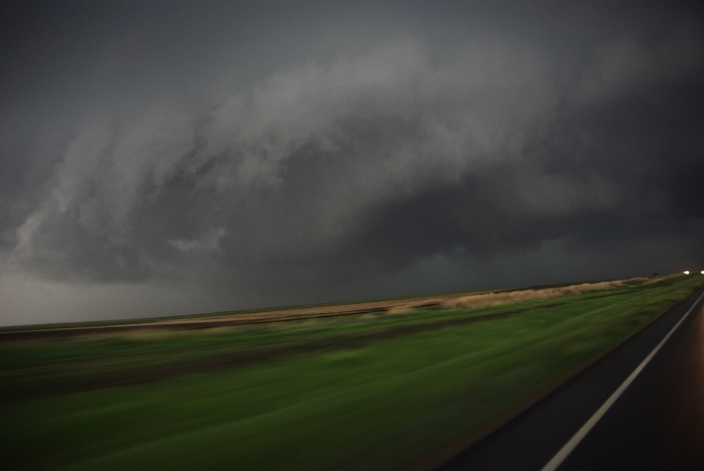
Atmospheric Stability
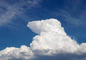
In order to have cloud formation, the air must be unstable. Stable air means air does not want to rise up, cool, and condense thus weather conditions tend to be clear skies. Unstable air means the air wants to rise up, cool, and condense into clouds and potential storms. So why does air rise to begin with?
Convection occurs when air rises much like a hot air balloon. Because of albedo, some areas on the ground can get heated up more than other areas. Where the land heats up more, the air above also warms, becomes less dense, and rises. If the air rises high enough, it may cool and condense to create clouds and possible thunderstorms.
Convection occurs when air rises much like a hot air balloon. Because of albedo, some areas on the ground can get heated up more than other areas. Where the land heats up more, the air above also warms, becomes less dense, and rises. If the air rises high enough, it may cool and condense to create clouds and possible thunderstorms.
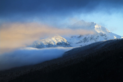
Orographic uplift occurs when air must rise over a mountain range. As the air rises over the mountain, the moisture within it may begin to cool and condense to form thunderstorms. Often times with orographic uplift, one side of the mountain will be very moist from the storms, while the other side is very dry. The dry side of the mountain is called the rainshadow effect. Later we will discuss how this process can generate what is called dry thunderstorms and wildfires.
 Image taken by NASA's MODIS satellite.
Convergence occurs when air is forced to rise because of low pressure above causing the rising air to cool and condense into clouds. One of the best examples of this is over Florida. Because Florida is a peninsula (surrounded by water on three sides), the land heats up more and the surrounding water. This causes the air above the land to rise. To replace this rising air cool, moist air from the Gulf of Mexico and Atlantic Ocean converges inward over Florida. Now this moist air is heated by the land and is forced upward to create powerful thunderstorms. In fact, Florida has more thunderstorms and lightning than any other state in the nation. Another good example of convergence is the eye of a hurricane.
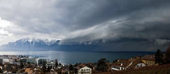
Finally weather fronts, such as cold fronts can force air to rise. A cold front occurs when a cold, dense air mass is replacing a warm, lighter air mass. The cold air mass plows through forcing the warmer air mass upward where is might cool and condense into clouds. But more on this in a minute.
Coriolis Effect
|
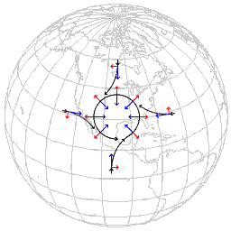
All free moving objects appear to be deflected to the right in the Northern Hemisphere (and to the left in the Southern Hemisphere) because of the rotation of the Earth. This apparent deflection is called the Coriolis effect. Think of it this way. If you wanted to through a football from Salt Lake City, Utah to Las Vegas, Nevada, you could not throw it from point A to point B. Why? Because as the football is moving toward Las Vegas, the Earth underneath is rotating. By the time the football gets to where Las Vegas was when threw the football, the city that never sleeps has moved off. Thus, if you want to throw a football from Salt Lake City to Las Vegas you would need to grow it ahead of the city in hopes that the football and Las Vegas meet up at the same time.
|

Both diagrams of the Coriolis effect were created by Roland Geider and licensed as Creative Commons.
|
|
|
|
|
Besides a football, what else is considered a "free moving" object. Free moving objects include airplanes, ocean currents, clouds, wind, hurricanes, or anything else that is not attached to the earth's surface. So how does this influence the atmosphere? As winds flow from high to low pressure, it deflects to the right (in the Northern Hemisphere) because of the earth's rotation. This deflection is nonexistent at the equator and progressively gets stronger towards the poles. Because of this, hurricanes can only form 5-20 degrees north or south of the equator. Near the equator, the water is warm enough but the Coriolis effect is too weak to make the hurricane rotate. Beyond 20 degrees latitude, the Coriolis effect is strong enough, but the waters are too cold.
|
|
Air Masses and Weather Fronts
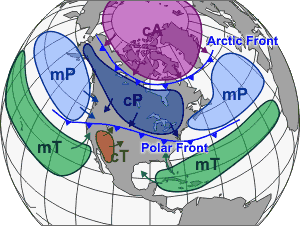
An air mass is a large body of air covering a relatively wide area and exhibiting horizontally uniform properties of moisture and temperature. The homogeneous of air masses comes from its source region. To create an air mass, the source region's surface must be fairly flat and uniform in composition (i.e. oceans, deserts, glaciers, etc.), but not a combination. If the air mass stays long enough within the source region, it will begin to develop the characteristics of that source region. An air mass is classified by their temperature and moisture and are identified by using a "letter code" system.
|
The first letter is always lower case and determines the moisture content within the air mass.
|
|
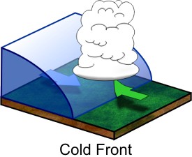
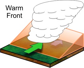
A weather front is a transition zone between two air masses of different densities, temperatures and/or moisture. When two air masses come into contact with each other, they do not like to mix well because of their different densities - much like water and oil. Along a weather front, the warmer, less dense air rises over the cooler, denser air to form clouds. There are several types of weather fronts, but we will only focus on two: cold fronts and warm fronts.
|
|
Cold fronts are zones separating two distinct air masses, of which the cooler, denser mass is advancing and replacing the warmer. The colder, more dense air pushes under the warm air forcing the warm, lighter air upward. If the warm air rising is unstable enough, large thunderstorms are likely to occur. Cumulous and cumulonimbus clouds are common. Warm fronts marks the boundary between a warm air mass that is replacing a cooler air mass. When a warm air mass advances over a cold air mass, the warm air rises over, but at a more gentler rate than a cold front. Since the warm air does not rise as fast as a cold front, more stratus clouds form and precipitation is not as heavy.
Mid-latitude Cyclones
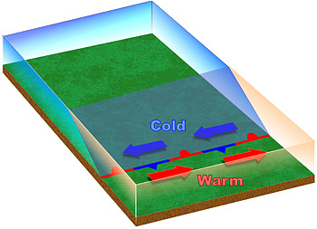
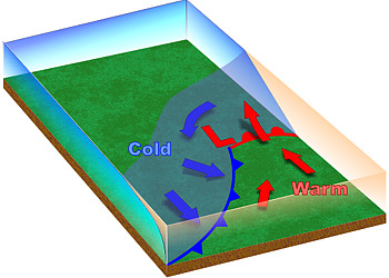
The polar front theory, also known as the Norwegian model, states that cyclones have a fairly predictable, six-stage life cycle. We will focus on the northern hemisphere for this section. It all begins along the polar front at 60-65 degrees north where two very different air masses with different densities meet. Clockwise rotation along the polar high air mass (cold, dense air) and the subtropical high air mass (warm, less dense air) causes air to flow parallel to each other along the polar front but in opposite directions. Where these two contrasting air masses meet is called a stationary front and cyclogenisis (formation of a mid-latitude cyclone) has begun.
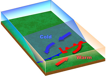
The wind shear, caused by the air flowing parallel but in the opposite direction from each other, creates a wave rotating counterclockwise along the polar front where warm subtropical air begins to migrate northward and cold polar air migrates southward. In the center of this rotating wave develops a low pressure rotating counterclockwise. The advancing boundary of the cold polar air is a cold front and the boundary of the advancing warm subtropical air is a warm front.
The wind shear, caused by the air flowing parallel but in the opposite direction from each other, creates a wave rotating counterclockwise along the polar front where warm subtropical air begins to migrate northward and cold polar air migrates southward. In the center of this rotating wave develops a low pressure rotating counterclockwise. The advancing boundary of the cold polar air is a cold front and the boundary of the advancing warm subtropical air is a warm front.
Stage 1
|
Stage 2
|
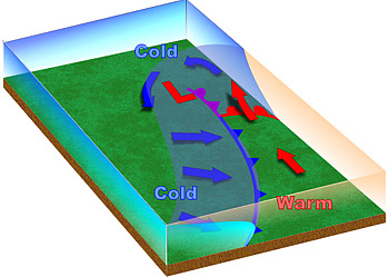
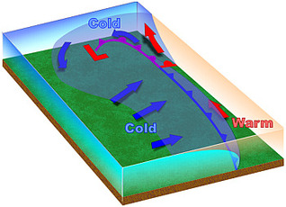
By stage three the midlatitude cyclone has a defined warm front and cold front. Uplifting of air begins to occur at this stage as the warmer, lighter, and moister air mass is forced to rise over the colder, heavier, and drier air mass. A massive amount of latent heat is being released as water vapor condenses to form clouds. This release of heat strengthens the low pressure (pressure drops more) and the atmosphere becomes more unstable.
What would it be like as the midlatitude cyclone approached? If you were in front of an advancing warm front, the air would be cool and stratus-type clouds would begin to develop. As the front approached you, the stratus clouds would lower until nimbostratus clouds were overhead.
Typically with warm fronts, the precipitation is light but may last a few days. Once the front passed you, it would actually feel warmer - thus a warm front. If you were in front of an advancing cold front, it would be warm at first with warm, southern winds blowing. Cumulus-type clouds would also begin to develop and lower as the cold front approached. Once the cold front is overhead, expect powerful cumulonimbus thunderstorms with the possibility of lightning and thunder, hail, strong winds, and intense precipitation in the form of rain or snow. Once the cold front has passed by, expect colder temperatures and winds from the north or northwest.
Stage 3
|
Stage 4
|
 Stage 4
As the days move on, the cold front might begin to "catch up" to the warm front and an occluded front forms. During this stage, the cold front forces the rest of the warm air from the warm front into the upper atmosphere. So now before the front passes the air is cool and afterward the air is cold. This is when the storm is most intense, the pressure drops further, and the winds are most intense (indicated by the isobars). But this also marks the end of the midlatitude cyclones life cycle. Once the warm air is forced upward, there is less latent heat thus less energy released into the storm. Remember that weather fronts marks the boundary between two high pressure air masses. So once the midlatitude cyclone moves off, high pressure tends to follow. The results are clear skies, little wind, and pressure rising. NOTE: Make sure to know how each of the weather fronts is drawn on a weather map.
Types of Precipitation


Rain is liquid water falling from nimbostratus or cumulonimbus clouds. Many times in the mid-latitudes, precipitation will fall from clouds in the form of snow which melts on its way down toward the ground.
Snow is precipitation in the form of ice crystals. The size, shape and concentration of snowflakes depends on the temperature they form in. When temperatures are very cold, snowflakes tend to be small to produce "powder". When the temperatures are warmer the snowflakes are larger.
Sleet is precipitation that falls as ice pellets. It occurs when precipitation falls from the base of a cloud in the form of snow. As the snow falls, it enters a region of warm air and melts into rain. But as the rain continues to fall, it enters a layer of cold air and refreezes in the form of ice pellets.
Freezing rain (also called glaze) is similar to sleet except for the last step. As the rain falls, it enters a layer of cold air. But the rain is not in this cold region long enough to freeze. Instead is stays as supercooled raindrops. But once the supercooled raindrops reach the ground, they freeze instantly on any object it touches.
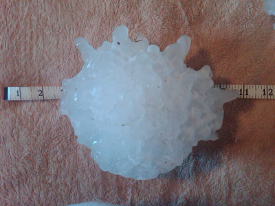
Hail is precipitation in the form of hard pellets of ice and only forms in cumulonimbus clouds where the lower region of the cloud contains liquid water and is above freezing, while the upper region is below freezing. When an ice pellet falls within the cumulonimbus cloud, it enters the warm, liquid region and picks up moisture. Then the updrafts through the ice pellet back up above the freezing point hardening the newly gathered water. The ice pellet will fall again to collect liquid water and thrown back up to refreeze. This process will continue until the weight of the hail stone becomes to heavy for the updrafts to hold it up. Once the hail becomes too heavy, the hail will precipitate from the cloud.
Snow is precipitation in the form of ice crystals. The size, shape and concentration of snowflakes depends on the temperature they form in. When temperatures are very cold, snowflakes tend to be small to produce "powder". When the temperatures are warmer the snowflakes are larger.
Sleet is precipitation that falls as ice pellets. It occurs when precipitation falls from the base of a cloud in the form of snow. As the snow falls, it enters a region of warm air and melts into rain. But as the rain continues to fall, it enters a layer of cold air and refreezes in the form of ice pellets.
Freezing rain (also called glaze) is similar to sleet except for the last step. As the rain falls, it enters a layer of cold air. But the rain is not in this cold region long enough to freeze. Instead is stays as supercooled raindrops. But once the supercooled raindrops reach the ground, they freeze instantly on any object it touches.
Hail is precipitation in the form of hard pellets of ice and only forms in cumulonimbus clouds where the lower region of the cloud contains liquid water and is above freezing, while the upper region is below freezing. When an ice pellet falls within the cumulonimbus cloud, it enters the warm, liquid region and picks up moisture. Then the updrafts through the ice pellet back up above the freezing point hardening the newly gathered water. The ice pellet will fall again to collect liquid water and thrown back up to refreeze. This process will continue until the weight of the hail stone becomes to heavy for the updrafts to hold it up. Once the hail becomes too heavy, the hail will precipitate from the cloud.
Atmospheric Pollution
ATMOSPHERIC POLLUTION POINT SOURCES
Contrary to what many think, air pollution can be caused by natural processes besides human activities. Under the rules governed by the Clean Air Act, the Environmental Protection Agency (EPA) monitors a wide range of emissions, the substances released into the atmosphere, such as ground ozone, particulate matter, carbon monoxide, nitrogen dioxide, sulfur dioxide, lead, and even carbon dioxide.
Natural processes contribute to a large portion of the earth's air pollution. Dust storms in arid regions, smoke and soot from grassland or forest fires, and volcanic ash are just a few. Human activity can also enhance atmospheric pollution from natural processes. When humans overuse the land, stripping the land of organic soil, plant material, and even water, the ground becomes bare and sandy. Winds can pick up and erode these particles to generate huge dust storms.
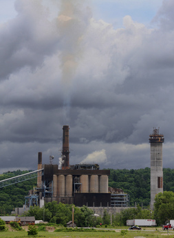
Humans can also pollute the atmosphere through activities such as driving cars and industrial practices such as the production of energy from fossil fuels. When emissions come from a central point, it is called a point source. This again would include industrial buildings and coal power plants. Emissions coming from non-stationary sources such as vehicles, airplanes, and trains are called non-point sources.
Another important concept to understand with air pollution is whether it's a primary or secondary pollutant. Primary pollutants is the emission of pollutant particles directly into the troposphere. They are called primary because they may cause human or environmental harm when they are directly emitted into the atmosphere. Examples of primary pollutants are carbon monoxide, soot, and mercury. When a primary pollutant chemically interacts with another pollutant or substance, it can create a secondary pollutant. For example, when sulfur dioxide reacts with precipitation, it creates sulfuric acid - acid rain. Another secondary pollutant is tropospheric ozone, which is created when nitrogen oxides and volatile organ compounds interact with sunlight and heat.
As noted above, acid rain is a secondary pollutant. When sulfur dioxide and nitrogen oxides combine with water, oxygen, and other substances, it forms acid precipitation. Many call this acid rain, but it can refer to any forms of precipitation. The source points of acid precipitation are automobiles, electrical power plants, and other industrial processes, which emit sulfur dioxide and nitrogen oxides. When this precipitation falls to the Earth's surface, it is called acid deposition. Often times acid deposition occurs far from the point source because of wind. Areas effected by acid deposition far away from the source are called downwinders. This is a problem in the United States where industrial states such as Pennsylvania and Ohio emit these pollutants, but the people in the eastern states receive the acid deposition. The same occurs in Eastern Europe where their industrial technology is not as advanced as Western Europe.
There are a wide range of effects by acid deposition. Because this form of precipitation is much more acidic than natural water droplets, ecosystems can be impacted, damaged, or destroyed. Acid precipitation and deposition can cause lakes to become too acidic, killing off fish and plant species. Acid deposition can also seep into soils, reaching root systems of plants killing off entire forests. In regards to humans structures, acid deposition can erode buildings, statues, and other structures. Many historical sites, such as the Parthenon from ancient Greece, are slowing being destroyed by acid deposition.
HEATH EFFECTS OF AIR POLLUTION
Most of us have seen the images of atmospheric pollution in major cities like Los Angeles, California or Beijing in China. During the Beijing Summer Olympics in 2008, many athletes boycotted the world event because the air quality was so bad. The athletes were concerned that competing in those olympics could in the long-term hurt their athletic careers.
There are several concerns about how air quality impacts human health. When humans breath dust and other particles, it can irritate their lungs causing them to cough. Long-term exposure to this type of pollution can cause asthma, bronchitis, and emphysema. The demographics of people most impacted by this expose tends to be elderly, children, and those with respiratory problems. That is why governmental agencies monitor the amount of particulates in the atmosphere and are communicated to the public through red, yellow, or green air quality days.
Carbon monoxide can also greatly impact human health. When humans breath, the oxygen that enters the body chemically binds with hemoglobin molecules in red blood cells. This allows the blood cells to transport and deliver oxygen throughout the body. But when carbon monoxide is in the atmosphere, the molecule competes with oxygen molecules by attaching to hemoglobin molecules. This interfere with the body's ability to transport oxygen throughout the body because the carbon monoxide molecules have replaces the oxygen molecules. Over time, this could greatly damage body organs including the heart as it must pump harder to get oxygen to the cells. If carbon monoxide is too high in the atmosphere, it can create carbon monoxide poisoning in the body, leading to death.
Contrary to what many think, air pollution can be caused by natural processes besides human activities. Under the rules governed by the Clean Air Act, the Environmental Protection Agency (EPA) monitors a wide range of emissions, the substances released into the atmosphere, such as ground ozone, particulate matter, carbon monoxide, nitrogen dioxide, sulfur dioxide, lead, and even carbon dioxide.
Natural processes contribute to a large portion of the earth's air pollution. Dust storms in arid regions, smoke and soot from grassland or forest fires, and volcanic ash are just a few. Human activity can also enhance atmospheric pollution from natural processes. When humans overuse the land, stripping the land of organic soil, plant material, and even water, the ground becomes bare and sandy. Winds can pick up and erode these particles to generate huge dust storms.
Humans can also pollute the atmosphere through activities such as driving cars and industrial practices such as the production of energy from fossil fuels. When emissions come from a central point, it is called a point source. This again would include industrial buildings and coal power plants. Emissions coming from non-stationary sources such as vehicles, airplanes, and trains are called non-point sources.
Another important concept to understand with air pollution is whether it's a primary or secondary pollutant. Primary pollutants is the emission of pollutant particles directly into the troposphere. They are called primary because they may cause human or environmental harm when they are directly emitted into the atmosphere. Examples of primary pollutants are carbon monoxide, soot, and mercury. When a primary pollutant chemically interacts with another pollutant or substance, it can create a secondary pollutant. For example, when sulfur dioxide reacts with precipitation, it creates sulfuric acid - acid rain. Another secondary pollutant is tropospheric ozone, which is created when nitrogen oxides and volatile organ compounds interact with sunlight and heat.
As noted above, acid rain is a secondary pollutant. When sulfur dioxide and nitrogen oxides combine with water, oxygen, and other substances, it forms acid precipitation. Many call this acid rain, but it can refer to any forms of precipitation. The source points of acid precipitation are automobiles, electrical power plants, and other industrial processes, which emit sulfur dioxide and nitrogen oxides. When this precipitation falls to the Earth's surface, it is called acid deposition. Often times acid deposition occurs far from the point source because of wind. Areas effected by acid deposition far away from the source are called downwinders. This is a problem in the United States where industrial states such as Pennsylvania and Ohio emit these pollutants, but the people in the eastern states receive the acid deposition. The same occurs in Eastern Europe where their industrial technology is not as advanced as Western Europe.
There are a wide range of effects by acid deposition. Because this form of precipitation is much more acidic than natural water droplets, ecosystems can be impacted, damaged, or destroyed. Acid precipitation and deposition can cause lakes to become too acidic, killing off fish and plant species. Acid deposition can also seep into soils, reaching root systems of plants killing off entire forests. In regards to humans structures, acid deposition can erode buildings, statues, and other structures. Many historical sites, such as the Parthenon from ancient Greece, are slowing being destroyed by acid deposition.
HEATH EFFECTS OF AIR POLLUTION
Most of us have seen the images of atmospheric pollution in major cities like Los Angeles, California or Beijing in China. During the Beijing Summer Olympics in 2008, many athletes boycotted the world event because the air quality was so bad. The athletes were concerned that competing in those olympics could in the long-term hurt their athletic careers.
There are several concerns about how air quality impacts human health. When humans breath dust and other particles, it can irritate their lungs causing them to cough. Long-term exposure to this type of pollution can cause asthma, bronchitis, and emphysema. The demographics of people most impacted by this expose tends to be elderly, children, and those with respiratory problems. That is why governmental agencies monitor the amount of particulates in the atmosphere and are communicated to the public through red, yellow, or green air quality days.
Carbon monoxide can also greatly impact human health. When humans breath, the oxygen that enters the body chemically binds with hemoglobin molecules in red blood cells. This allows the blood cells to transport and deliver oxygen throughout the body. But when carbon monoxide is in the atmosphere, the molecule competes with oxygen molecules by attaching to hemoglobin molecules. This interfere with the body's ability to transport oxygen throughout the body because the carbon monoxide molecules have replaces the oxygen molecules. Over time, this could greatly damage body organs including the heart as it must pump harder to get oxygen to the cells. If carbon monoxide is too high in the atmosphere, it can create carbon monoxide poisoning in the body, leading to death.
Temperature Inversions
Recall from earlier in the chapter that atmospheric temperature tends to decrease with height, called the environmental lapse rate. A temperature inversion occurs when this is reversed, when air temperatures actually increase with height. This is actually a normal process, and common in valleys surrounded by mountains. When high pressure moves over Earth's surface for several days, the lack of wind and atmospheric circulation causes the colder, dense air to settle to the bottom of the earth's surface and the lighter, less dense air to rise above. Thus, air temperatures are warmer higher up and colder toward the ground.
The problem with atmospheric inversions is that this also sets the conditions to allow primary and secondary pollution to become trapped because no wind is mixing the atmosphere. The "soup" of pollution caused by an inversion is called smog. The term came from the London during the beginnings of the Industrial Revolution when smoke and fog would mix together making extremely unhealthy air conditions. Today there are two types of smog: industrial and photochemical. Industrial smog is a mixture of sulfur compounds, soot, and precipitation. Governmental regulations such as the U.S. Clean Air Act has dramatically reduced this form of smog by requiring improved technology and regulation. But industrial smog is still a serious problem for developing nations such as China and eastern European nations.
The term "photo" usually refers to light, so photochemical smog occurs when nitrogen oxides one hydrocarbons reacts with sunlight to produce a brownish haze in the atmosphere. This tends to produce tropospheric ozone, a secondary pollutant, in the atmosphere. Tropospheric ozone is nearly identical to the ozone found in the stratosphere that makes up the ozone layer. But whereas the ozone layer protects all of life on the planet, tropospheric ozone can greatly damage living organisms and tissue. The main source of photochemical smog is exhaust generated by vehicles, a non-point source of pollution. To reduce photochemical smog, humans need to improve vehicle technology (i.e. natural gas, hybrid, electric, improve miles per gallon), vehicle inspections to repair cars and trucks that emit a lot of pollution, along with changing driving habits such as mass transit or creating walking communities.
Environmental Regulation
CLEAN AIR ACT
In the 1960s and 1970s, the U.S. Congress enacted several acts such as the Endangered Species Act, the Clean Water Act, and the Clean Air Act. Under the Clean Air Act, the Environmental Protection Agency is charged to monitor and regulate the nation's air quality for human and environmental health. The goal is to lower the risk of asthma and cancer along with reducing smog and acid deposition. In order to do this, the EPA partners with state governments to focus on the following key elements:
MONTREAL PROTOCOL
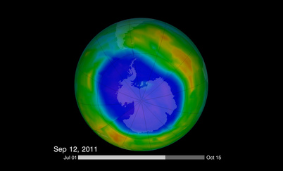
The ozone layer is found in the stratosphere, the next layer up from the troposphere. Though ozone is a pollutant in the troposphere, it is vital for life in the stratosphere, where it absorbs most of the harmful ultraviolet radiation (UV) from the Sun before it reaches Earth's surface (see video). Ultraviolet radiation can damage skin cells causing skin cancer. The ozone layer is made up of ozone, which is basically three oxygen molecules bonded together. When UV radiation from the sun reaches the stratosphere, one of the oxygen molecules breaks off creating a single oxygen molecule and a two-oxygen molecule that humans can breath. But at the same rate that the ozone molecule is destroyed by UV radiation, the single oxygen molecule rebonds with the two-oxygen molecule to reform ozone. So under normal conditions, the ozone layer is considered in an equilibrium where it is being destroyed and reformed at an equal rate (see video).
In 1974 two American scientists, Mario Molina and Sherwood Rowland, predicted that the ozone layer was being damaged or destroyed by a human compound created by humans called chlorofluorocarbons (CFCs). These molecules, a chemical compound of chlorine, fluorine, and carbon were created and manufactured as cooling agents for refrigerators, air conditioning, foaming agents to fight fires, and for aerosol spray cans. In the troposphere, CFCs are very stable molecules. But if they reach the stratosphere, the chlorine molecule could be broken off by UV radiation and attach itself to an ozone molecule (see video). When attached, the the chlorine molecule breaks off one of the ozone molecules, destroying the ozone molecule. CFCs can stay active in the stratosphere for over 50 years and it is believed that each chlorine molecule can destroy over 100,000 ozone molecules. Thus, the ozone layer is no longer in equilibrium because today more ozone molecules are being destroyed than reforming.
The two noted scientists above won the Noble Prize in Chemistry for accurately predicting that CFCs were destroying the ozone layer. So in 1987, several leading nations including the United States, met in Montreal, Canada to discuss a treaty to phase out the use of CFCs. This treaty became known as the Montreal Protocol, began the phase out of CFCs by major industrialized nations. Today, CFCs and other ozone depleting molecules have fallen nearly 95 percent since the signing and ratifying of the treaty. Satellite data is starting to show a gradual improvement of the ozone layer and a diminishing of the ozone hole over Antarctica. But since CFCs have such a long life expectancy in the stratosphere, it will be some time before the ozone layer has fully recovered. Many argue that the Montreal Protocol is the greatest environmental success story, because so many nations worked together for a global cause. Many hope that someday climate change will be another success story.
In the 1960s and 1970s, the U.S. Congress enacted several acts such as the Endangered Species Act, the Clean Water Act, and the Clean Air Act. Under the Clean Air Act, the Environmental Protection Agency is charged to monitor and regulate the nation's air quality for human and environmental health. The goal is to lower the risk of asthma and cancer along with reducing smog and acid deposition. In order to do this, the EPA partners with state governments to focus on the following key elements:
- reduce outdoor, or ambient, concentrations of air pollutants that cause smog, haze, acid rain, and other problems;
- reduce emissions of toxic air pollutants that are known to, or are suspected of, causing cancer or other serious health effects; and
- phase out production and use of chemicals that destroy stratospheric ozone.
MONTREAL PROTOCOL
The ozone layer is found in the stratosphere, the next layer up from the troposphere. Though ozone is a pollutant in the troposphere, it is vital for life in the stratosphere, where it absorbs most of the harmful ultraviolet radiation (UV) from the Sun before it reaches Earth's surface (see video). Ultraviolet radiation can damage skin cells causing skin cancer. The ozone layer is made up of ozone, which is basically three oxygen molecules bonded together. When UV radiation from the sun reaches the stratosphere, one of the oxygen molecules breaks off creating a single oxygen molecule and a two-oxygen molecule that humans can breath. But at the same rate that the ozone molecule is destroyed by UV radiation, the single oxygen molecule rebonds with the two-oxygen molecule to reform ozone. So under normal conditions, the ozone layer is considered in an equilibrium where it is being destroyed and reformed at an equal rate (see video).
In 1974 two American scientists, Mario Molina and Sherwood Rowland, predicted that the ozone layer was being damaged or destroyed by a human compound created by humans called chlorofluorocarbons (CFCs). These molecules, a chemical compound of chlorine, fluorine, and carbon were created and manufactured as cooling agents for refrigerators, air conditioning, foaming agents to fight fires, and for aerosol spray cans. In the troposphere, CFCs are very stable molecules. But if they reach the stratosphere, the chlorine molecule could be broken off by UV radiation and attach itself to an ozone molecule (see video). When attached, the the chlorine molecule breaks off one of the ozone molecules, destroying the ozone molecule. CFCs can stay active in the stratosphere for over 50 years and it is believed that each chlorine molecule can destroy over 100,000 ozone molecules. Thus, the ozone layer is no longer in equilibrium because today more ozone molecules are being destroyed than reforming.
The two noted scientists above won the Noble Prize in Chemistry for accurately predicting that CFCs were destroying the ozone layer. So in 1987, several leading nations including the United States, met in Montreal, Canada to discuss a treaty to phase out the use of CFCs. This treaty became known as the Montreal Protocol, began the phase out of CFCs by major industrialized nations. Today, CFCs and other ozone depleting molecules have fallen nearly 95 percent since the signing and ratifying of the treaty. Satellite data is starting to show a gradual improvement of the ozone layer and a diminishing of the ozone hole over Antarctica. But since CFCs have such a long life expectancy in the stratosphere, it will be some time before the ozone layer has fully recovered. Many argue that the Montreal Protocol is the greatest environmental success story, because so many nations worked together for a global cause. Many hope that someday climate change will be another success story.
